The Course
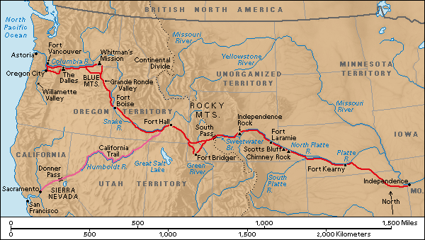
The Oregon trail began in Independance, Missouri, a perfect name considering those who left it, sought more independance. The trail stretched approximately 1930 miles across the country to Oregon City, Oregon. Along the way there were 5 major Forts where wagons stopped to restock and repair. These were Fort Kearny, Fort Laramie, Fort Bridger, Fort Hall, and Fort Boise. However, there was not just one single route, there was many. But there was one goal, their destination: Oregon's Willamette Valley.
Rules soon were established on the trail; up at dawn, on the road by seven, no swearing, a "nooning" for a cold meal. No alcohol was drank, except for medicinal purposes. Drive fifteen miles a way, and walk on your own feet nearly the whole way.
Grave sites became rather common, and as the trail grew older, it became careless to how the people were buried. The first sites of death, however, were well maintained, you could see the mourning and the care put into them as you walked by.
As you head across Kansas and Nebraska, the Oregon Trail is connected by the road from St. Joseph. For several hundred miles it was dotted by Pony Express stations. Rock Creek Station in Nebraska was the site of a shooting that brought "Wild Bill" Hickok to fame. The Platte River was the major landmark and highway acorss the plains. All the trails followed the river.
Fort Kearny and Laramie were owned by the U.S. Army. Fort Bridger was a fur trading post. Forts Boise and Vancouver were Hudson's Bay Company trading posts, and later on Fort Hall became a post of theirs as well. Fort Kearny had all the signs of being a true city, including a post office.
Famous landmarks of the trail include Courthouse and Jail Rocks, Chimney Rock, Scotts Bluff, and Independance Rock. Still today, many of them have the names of pioneers craved into them.
At certain points in the trail, when it was flat, wagons would fan out so no one would eat eachother's dust. But in several places the trail got smaller, and wagons had to follow in single file. There were shortcuts where emigrants and gold miners, who didn't want to pass by the Forts, would take. In 1841 and 1842 the land route ended at Fort Walla Walla, and the Walla Walla River began. From there you chaulked you wagon into a raft, and headed down the river. For the next three years, the land ended at The Dalles, where you could build a raft, or ditch your wagon for British bateaux to Fort Vancouver and your final destination, Oregon City. When 1846 hit Mount Hoob became the pregerred route for 66% of all travelers, except in 1847 and 1852 when snow closed the route.
In the end, if you made it to Oregon City in full health, you were lucky. But once there, you could begin your new life.
